
Investigating the ever-growing and flourishing uses of UAVs in agriculture
Author: Arham Elahi, Leonardo Times Editor and Naomi Lijesen, Final Editor
Optimizing the agricultural industry is of the utmost importance. Currently, we technically have enough food on the planet to sustain everyone, even though it is tragic that it is not equally distributed. However, the current world population of 7.6 billion is expected to grow by a third, or 2.3 billion, by 2050 – thus, global food production must rise by about 70% to meet this demand [1][2]. Of course, clearing such an enormous area of land to facilitate more agriculture is not a sustainable solution when considering climate change and the strain humans put on the environment. Therefore, instead of the increasing area, we must look to increase efficiency. That’s where drones come in.
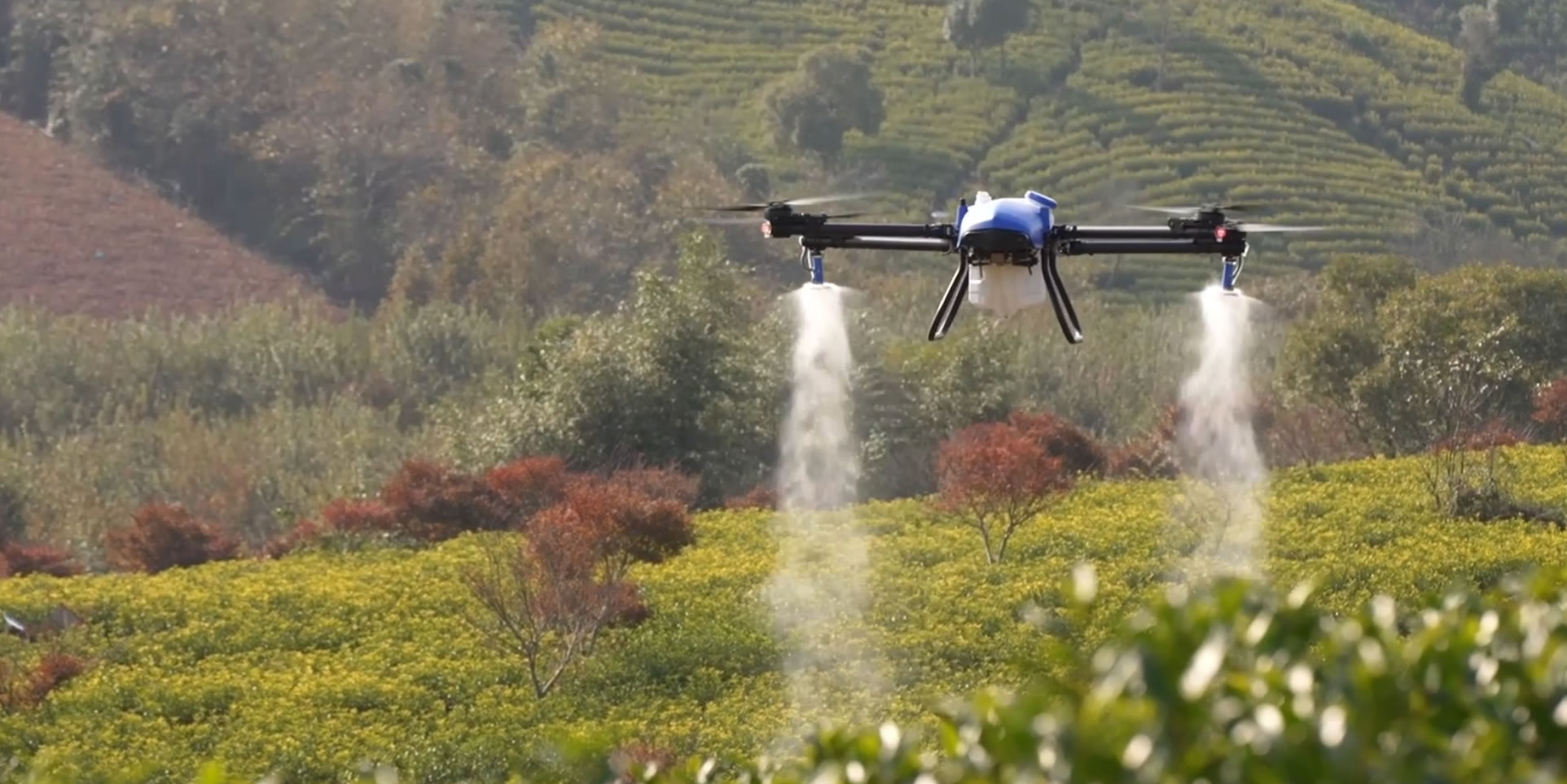
In recent decades the operations of agriculture have evolved considerably alongside technology. A portion of this can be credited to drones and other unmanned aerial vehicles (UAVs) improving the efficiency of farming processes-including aerial surveying, crop sowing and fertilization, livestock management, soil and water analysis and pest control [3].
PRECISION AGRICULTURE
Typically, the improvement in crop yield gained from new technologies such as drones is called Precision agriculture (sometimes also known as Smart Farming) [4]. Precision agriculture ensures that the plants (or animals) get exactly what they need to thrive as established by a predetermined method that heavily relies on new technologies. Regarding crops; this usually involves a process of observation, diagnostics, decisions and finally implementation [4]. First, an array of sensors records observational data from the crops, soil and/or water levels. Then using this data, the health and state of the crops are assessed and run through models to determine what specific treatment plans are required. Lastly, the machines must carry out these treatments correctly. Whereas before, farmers applied treatments based on the average state of the whole area; now they can capture precise measurements on individual areas [5]. Therefore, precision spraying can use this precise and location-specific data to ensure an increase in crop yield and crop quality while reducing waste [5]. 3D contour imaging of an area can also be compiled before sowing seeds, allowing farmers to place crops more strategically [5].
UAVs are very versatile and can carry out multiple roles. So, the same drone can accomplish field and terrain mapping as well as spraying of both solid and liquid products, such as; seeds, fertilizer, pesticides (herbicides, fungicides) and desiccants [9]. Along with the many aforementioned capabilities of drones, they can also treat many types of crops such as rice, wheat, corn, fruit trees, cotton, etc. AI-powered software is thought to be the key to efficiently educating drones so that they can treat and learn about a wide range of crops, each with its diseases and specific needs [11]. Additionally, where farmers traditionally monitored conditions visually, asking professionals to conduct tedious soil analysis by sending samples to labs. Now, with the appropriate equipment, a drone could potentially fly over a field and return to the farmer with a full report of the plants’ health and quantity. What used to be an extraordinarily inefficient process for large-scale farming is now economical. The American Farm Bureau Federation (AFBF) conducted a study with drone software company Measure in 2015 and found an impressive return on investment (ROI) when deploying drones for crop scouting and 3D terrain mapping [10]. All three of the crop types examined showed positive returns in reduced costs and increased efficiencies [10].
DRONES AND LIVESTOCK
As with crop surveying, drones and UAV can monitor herds [6]. Particularly on very large ranches and farms, free-roaming animals can wander off. Drones can move fast, independent of the terrain type and hence, can quickly cover hundreds of acres to locate herds. Real-time visuals and snapshots can survey herds, and intelligent systems can make counts of animals, serving as a literal ‘eye in the sky’. Deploying a thermal camera on the drone could also allow farmers to diagnose sick livestock by signature elevated body temperature [6]. Additionally, farmers can use the drone’s vegetation surveying techniques to find optimal foraging or grazing across large areas. With the classic drone video visuals, farmers can also assess the strength of their furthest fences and gates. Potentially, these videos can be made autonomously by the drone which the farmers can then review to keep ahead of their repairs and ensure security. These same drone surveillance capabilities can ensure farm security and avoid theft not only of livestock but other farm apparatus [7].
ENVIRONMENTAL BENEFITS
Drones can offer environmental benefits – they can more efficiently distribute the spray of pesticides to attain the same overall effect with less product consumption. Using fewer pesticides is advantageous as there is reduced collateral in terms of water and soil pollution and harming non-target organisms or animals [9]. For farmers, this is particularly helpful to stay in keeping with pesticide reduction regulations [5].
MINIMIZING HEALTH RISKS
UAV usage in agriculture can also reduce the number of health risks that farmers once had to endure. Drones hugely minimize the hard labor involved in regular crop treatments. From spreading seeds to spraying, the manual effort required to operate these aircraft is remarkably low [5]. Besides this, by using drones, farmers decrease the exposure to toxic pesticides that can otherwise cause problems such as respiratory issues, hematological alterations, infertility and an increased risk of certain cancer types [8]. Drones add an element of safety by reducing the risk of farmers having to travel across huge stretches of land and uneven terrain
A CLOSER LOOK AT DRONE SENSOR TECHNOLOGIES
Aside from the aforementioned passive benefits, drones also open up a wide array of new possibilities to facilitate agriculture. Paving the path for these are cameras and sensors which can map out entire fields and investigate the land’s potential for potential agriculture or even investigate agricultural land to find fertile patches of land suited for particular crops.
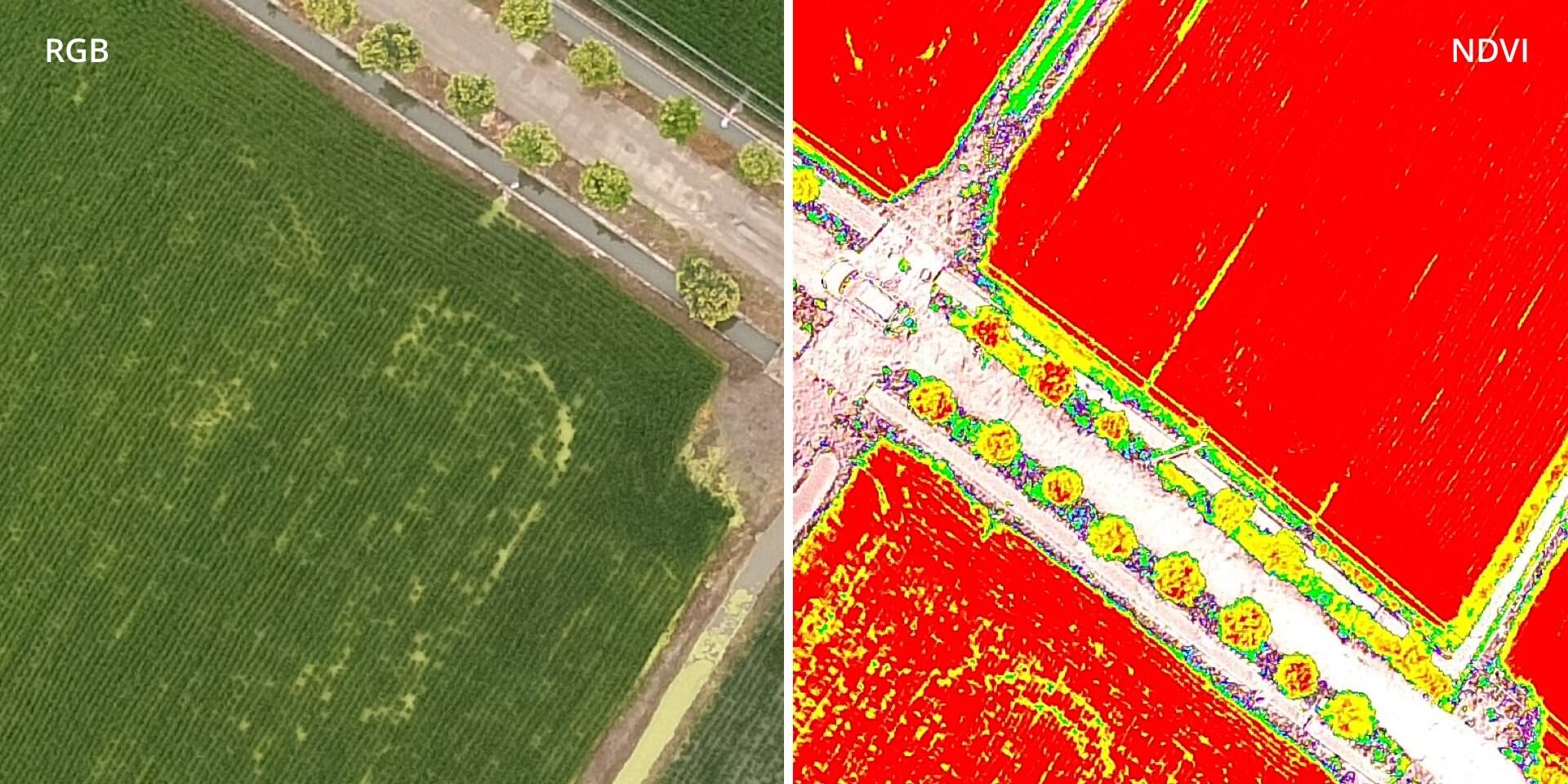
Drones mainly use a combination of three types of camera sensors; RGB (Red, Green and Blue), thermal and multi-spectral. The health and progress of the harvest can be monitored through the birds-eye view provided by the RGB cameras. Multispectral cameras provide NDVI (Normalized Difference Vegetation Index) maps which describe the greenness and density of vegetation expressed as numbers between -1 and 1. NDVI maps are generally used for predicting droughts and detecting the malnourishment of plants. An example is shown in the figure below.
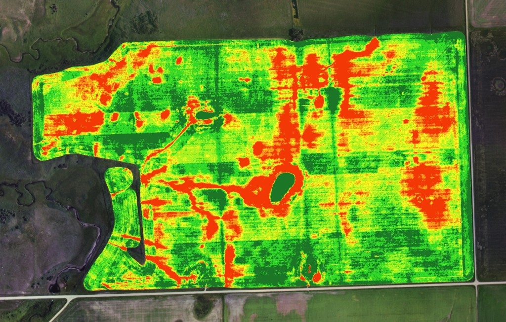
Thermal imaging allows for soil moisture estimation, which, combined with automated irrigation optimizes water usage whilst preventing waterlogging plants. This is vital in multi-crop fields where traditional irrigation has major shortcomings due to the variability in uptake between different plants. An example is shown in the figure.
Multi-spectral cameras also allow for soil analysis based on the electromagnetic spectrum of light reflected from the ground giving farmers real-time feedback on the condition of the land. Note that a satellite can complete most of the above functions as well, but the drones allow a farmer far more flexibility, functionality and independence while being substantially more accurate (to the millimeter compared to the meter). They also are not affected by cloud cover or other atmospheric interventions that may reduce visibility. The cost of drones has the potential to be much lower than that of satellites and the response time from satellites is extremely slow when compared to a UAV. However, drones do cover a much smaller area than satellites and a farmer may need several drones of each type to monitor their entire field [5].
UAVS ARE BUSY BEES
Another fascinating use for drones is the potential as pollinators. The population of small insects and bees are declining rapidly and many species are in danger of extinction. They are integral to the ecosystem, playing a vital role in the reproduction of plants by enabling pollination from one flower to another. About three-fourths of global crop production relies partially on insect pollination, and about 35% of global food production is partially dependent on insects [16]. Manual pollination is possible but extremely labor intensive and machine-blown plumes of pollen are very inefficient and lead to a lot of wasted pollen. In response to this predicament, two types of drones have currently been pitched as pollinators. One of them is a minuscule drone approximately the size of a bee with a horsehair brush attachment coated in a specialized gel that retains its stickiness over multiple uses [14]. This enables it to transfer pollen in a very similar fashion to natural pollinators. However, currently, it is difficult to automate the process without damaging the delicate insides of the flowers. The other concept is to use bubbles filled with pollen that will pop when coming into contact with the plant. Although more efficient than machine-blown plumes, it is still less efficient than natural pollinators and it is speculated that the substances that compose the bubble could drive off natural pollinators [13][15]. It is important to note that they are preliminary concepts far from being ready for commercial use. One important detail to note is that we should not aim to replace natural pollinators, but the drone system should complement the natural system and help the farmer reach optimal yield. The survival of bees and other insects is still imperative – after all, drones can’t produce honey.
AGRICULTURAL DRONE COMPANIES
PrecisionHawk is a commercial drone and data company based in North Carolina, USA. They provide the service of ‘PrecisionAnalytics Agriculture’, an aerial mapping and analytics platform, using DJI’s Matrice 200 V2 and its cousin, the Phantom series. They offer a training service to teach users how to operate drones or provide professionals to fly them. At the end of the service, farmers receive a prescription map transferred directly into a farm management system [12]. They connect this service by creating coherent documents that farmers can share with the claims department of their crop insurance, outlining the state of their crops.
DJI, the China-based technology company, boasts a fleet of drones for personal photography use, as well as specialized agricultural drones. Its largest is the six-rotor DJI Agras T30, with a tank capacity of thirty liters and a maximum spray flow of eight liters per minute, it can cover forty acres per hour. Its sixteen nozzles provide a spray range of nine meters and it can be folded down to 20% of its normal size. As well as liquid spraying, it allows the spreading of forty liters worth of solid pellets. As for sensors, it’s fitted with an omnidirectional radar for locating obstacles to make automatic detours and two front and rear FPV cameras. To complement this drone, DJI also released the lightweight ‘little brother’ Agras T10 with a tank capacity of eight liters [21].
EAvision is another drone company that was established in 2015, is based in the USA and specializes in AI autonomous control and binocular visual perception. Binocular perception is related to the use of two cameras to capture an image, thus enhancing the image and adding depth perception. The company’s reach expands from the US to Oceania, South America and Europe, while also covering major parts of Asia. The AI technology allows the drone to function 24 hours a day on any terrain. Their flagship model, the EA-30X can carry payloads up to 30 kilograms and can pump out 0.5-10 L of liquid every minute. The 29000 mAh battery can be recharged within 8 to 10 minutes and lasts 8.3 minutes with a full load [19].
CONCLUSION
The impressive technological applications in this field are vast, crucial and flourishing. With companies all over the tech world looking to put sustainability as their principal intention, this sector won’t be omitted. A wonderful example is the Canadian company FlashForest coupling pressurized air cannons on UAVs to plant trees with their ethos of ‘Automating reforestation’ seems in grasp [22]. Whilst the sector has seen an explosion of growth in recent years, there is still more to come, with the agricultural drone market size forecast at $1 billion by 2024 [20]. The technology is arguably too speedy, with regulations limiting the use of drones. In many areas, drones are currently not permitted to operate BVLOS (Beyond Visual Line of Sight). While it need not interfere with spraying capabilities, it will inevitably restrict the automation capabilities. But, as public opinion shifts and drone safety further improves, perhaps the rules will catch up; then the sky’s the limit.
REFERENCES
[1] United Nations. (2017). World population projected to reach 9.8 billion in 2050, and 11.2 billion in 2100. https://www.un.org/en/desa/world-population-projected-reach-98-billion-2050-and-112-billion-2100
[2]Food and Agriculture Organization. (2009, October 12-13). Global Agriculture Towards 2050. https://www.fao.org/fileadmin/templates/wsfs/docs/Issues_papers/HLEF2050_Global_Agriculture.pdf
[3] Consortiq. Drones in Agriculture. Retrieved Sept 2022 from https://consortiq.com/uas-resources/using-drones-in-agriculture-industry
[4] Wageningen University and Research. Precision Agriculture – Smart Farming. Retrieved Sept 22 2022 from https://www.wur.nl/en/dossiers/file/dossier-precision-agriculture.htm
[5] Precision Agriculture with Drone Technology. (December 22, 2021). Enterprise. https://enterprise-insights.dji.com/blog/precision-agriculture-drones
[6] Using drones to manage crops and livestock. (2022). PrecisionHawk. https://www.precisionhawk.com/agriculture/crops
[7] ZenaDrone. Farm Security Drone Monitoring. Retrieved Sept 22 2022 from
[8] de-Assis, M. P., Barcella, R. C., Padilha, J. C., Pohl, H. H., & Krug, S. (2021). Health problems in agricultural workers occupationally exposed to pesticides. 18(3), 352–363. https://doi.org/10.47626/1679-4435-2020-532
[9] The use of Drones in Agriculture Today. (September 18, 2021). Enterprise. https://enterprise-insights.dji.com/blog/drones-in-agriculture
[10] Aerial Intelligence Group. (2021, December 3). Drones deliver as high as 12:1 ROI in Agriculture. https://flyaig.com/newsroom/f/drones-deliver-as-high-as-121-roi-in-agriculture?blogcategory=Police
[11] Flynex. Smart Farming with Drone: Data Solutions for Digital Agriculture. Retrieved Sept 22, 2022 from https://www.flynex.io/agriculture/
[12] PrecisionHawk. Drone mapping and analytics for agriculture. Retrieved sept 22 2022 from https://www.precisionhawk.com
[13] Stokstad, E. (2020, June 17). Drone-delivered soap bubbles could help pollinate flowers. Science. Retrieved September 24, 2022, from https://www.science.org/content/article/drone-delivered-soap-bubbles-could-help-pollinate-flowers
[14] Chechetka, S. A., Yu, Y., Tange, M., & Miyako, E. (2017). Materially engineered artificial pollinators. Chem, 2(2), 224–239. https://doi.org/10.1016/j.chempr.2017.01.008
[15] Potts, S. G., Neumann, P., Vaissière, B., & Vereecken, N. J. (2018). Robotic bees for crop pollination: Why drones cannot replace biodiversity. Science of The Total Environment, 642, 665–667. https://doi.org/10.1016/j.scitotenv.2018.06.114
[16] Ritchie, H. (2021, August 2). How much of the world’s food production is dependent on pollinators? Our World in Data. Retrieved September 24, 2022, from https://ourworldindata.org/pollinator-dependence
[18] Using drones for Precision Agriculture. Uses of thermal imaging drones for precision agriculture. (2016). Retrieved September 24, 2022, from https://www.uaslogic.com/drones-for-precision-agriculture.html
[19] Eavision robotic. EAvision. (n.d.). Retrieved Sept 24, 2022, from https://eavisiontech.com/
[20] Bhutani, A. (2017, April). Agricultural Drones Market Size By Product , By Application , Industry Analysis Report, Regional Outlook, Application Potential, Price Trends, Competitive Market Share & Forecast, 2017 – 2024. Global Market Insights. https://www.gminsights.com/industry-analysis/agricultural-drones-market
[21] Technology Inspires Growth. DJI. Retrieved Sept 25 from https://ag.dji.com
[22] FlashForest. Automating Reforestation. Retrieved Sept 22 2022 from https://flashforest.ca.